Baron boosts WX graphics offering
Subscribe to NCS for the latest news, project case studies and product announcements in broadcast technology, creative design and engineering delivered to your inbox.

The Baron Services booth on the NAB Show floor. Photo: Dak Dillon/NewscastStudio
Baron has announced new features for its Omni offering:
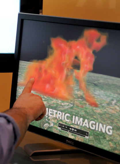
Volumetric radar imaging combines available radar scans and creates 3D maps that illustrate the data in ways viewers can understand.
In a demo Tuesday at NAB in Las Vegas, imagery from the Oklahoma May 3, 1999 tornado was shown with a detailed 3D look at the storm, including the various parts of the structure. Though highly technical it was obvious how, when combined with a meteorologist’s expertise, this system could provide a unique and vital view of storm systems.Baron has also added live video integration allows stations to import live or taped video in SD and HD as well as from IP or Web cameras.

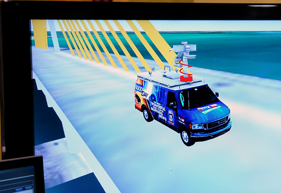
GPS integration allows stations to show where their vehicles are currently located to viewers. Photo: Dak Dillon/NewscastStudio
GPS integration allows stations to generate maps of reporter or crew locations based on data from cell phones, laptops or PDAs. The system can overlay 3D models or icons of helicopters or vehicles that change position in real-time.
The system can also jump from one area to another, a key feature to enhance storytelling during team coverage of major weather events.

Station helicopters can also be shown in full 3d with live video and 3d maps. Photo: Dak Dillon/NewscastStudio
3D models don’t stop with vehicles and aircraft; Baron can also render detailed 3D models of landmark buildings. These images can be combined with live video feeds or weather imagery to create enhanced views of the weather.

Volumetric imaging allows for detailed looks at storms. Photo: Dak Dillon/NewscastStudio
Surface-analysis graphs add another 3D element that plot the path of weather fronts. Weather information is combined with maps to provide a localized look at weather patterns and conditions.
Baron’s system also combines its massive database of weather data with satellite imagery to provide high-quality, real-time weather maps from any where in the world. During our demo, for example, Omni was used to show both the Iraq area, Mt. St. Helens and and Mt. Kilimanjaro, the latter complete with a live Web cam view. Overlays can show current conditions including temperatures and snow cover as well as future predictions.
The Omni system is render-less, meaning no preset timeline is needed for forecasters to use the system. They can, as the news warrants, zoom from one area of the world to another.
Subscribe to NCS for the latest news, project case studies and product announcements in broadcast technology, creative design and engineering delivered to your inbox.


tags
3D, Baron, maps
categories
Local News, NAB Show, Weather